

 English
 Russian
 Dutch
Dutch German
 Spanish
 French
 Türkçe
Detailed hi-res maps of Yuzhno-Sakhalinsk for download or print

City tours, excursions and tickets in Yuzhno-Sakhalinsk and surroundings
Car rental on OrangeSmile.com

Search for services, infrastructure and sights on map of Yuzhno-Sakhalinsk
Photogallery of Yuzhno-Sakhalinsk sightseeing


Our guide chapters over Yuzhno-Sakhalinsk
Travel guide to Yuzhno-Sakhalinsk
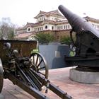
One of the most recognizable city attractions is the Local History Museum. It occupies the incredibly beautiful historic building that resembles the luxurious Japanese palace with its silhouette. The beautiful building was constructed in 1937. It is an architectural monument in the teikan yoshiki style. In the first half of the 20th century, Sakhalin Island belonged to the Japanese government. Today, the unique … Open 
Yuzhno-Sakhalinsk sightseeing
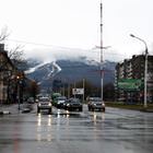
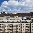
The beautiful far eastern city, Yuzhno-Sakhalinsk, is very attractive for modern tourists. Despite its remoteness from the European part of Russia, the city is visited by many guests. Most of them are attracted by the “eastern” atmosphere of the city. Yuzhno-Sakhalinsk was founded in 1882. For many years, Japan had been fighting for the right to have a better territory from a strategic point of view. In 1905, the … Open