

Printable maps of Cincinnati


Interactive maps of hiking and biking routes around Cincinnati
1. You can zoom in/out using your mouse wheel, as well as move the map of Cincinnati with your mouse.2. This interactive map presents two modes: 'Biking Routes' and 'Hiking Routes'. Use the '+' button on the map to switch between them.
Railway and landscape maps of Cincinnati area
This Cincinnati map has two modes: 'Railway Network' and 'Landscape & Rural Map'. Use the '+' button on the map to navigate.City tours, excursions and tickets in Cincinnati and surroundings
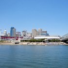
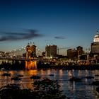
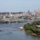
Photogallery of Cincinnati sights


Our guide to Cincinnati
Cincinnati sightseeing
Cincinnati occupies a special place among oldest American cities. It belongs to the cities of the US which have started the history of the country. A pig is the symbol of the city and it really deserves this title. Pig has been chosen not only because of local pork that is very famous. It was pork fat that gave the start to the "beauty industry" of the country. Nowadays the headquarters of the world's largest … Open 
Travel guide to Cincinnati
The most unusual historical symbol of the city is the suspension bridge named after Johann Röbling. It was constructed in 1866 and was the longest suspension bridge in the world by the time it had been finished. The length of the bridge is 322 meters. Exactly by its example, the famous Brooklyn Bridge was constructed. Guests resorts should certainly pay their attention to legendary skyscrapers, the most … Open