- Cologne Topics
- Travel guide
- Cuisine & restaurants
- Traditions & lifestyle
- Cultural sights
- Attractions & nightlife
- Tips for tourists
- Photo gallery
- High-resolution maps
- Interactive map
- Subway map
- Accommodation
- » Family rooms
- » Budget hotels
- » Luxury hotels
- » Apartments
- » Hostels
- » Hostels
- » Hotels with Internet
- Car rental
- Minivans, 9-seaters
Our fun photogalleries

Absolutely Best Rates for Hotels in Cologne
Maps of Cologne, Germany

About this map
You can open, download and print this detailed Cologne map by clicking on the map above or via this link: Open the city map.
You can open, download and print this detailed Cologne map by clicking on the map above or via this link: Open the city map.
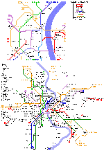
Metro / underground map of Cologne

About this map
The subway map of Cologne you can open, download and print by clicking on the map above or via this link: Open the map of Cologne metro.
The subway map of Cologne you can open, download and print by clicking on the map above or via this link: Open the map of Cologne metro.
Other detailed maps of Cologne


Travel Video Guide about Cologne
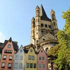
Live photogallery of Cologne, Germany


Our articles about Cologne:
Travel guide to Cologne
The House of Cologne 4711. The House of Cologne 4711 is a world-known shop in Cologne, where one can buy the ' cologne. The house is situated in Glockengasse. 'Eau de...
Read further
The House of Cologne 4711. The House of Cologne 4711 is a world-known shop in Cologne, where one can buy the ' cologne. The house is situated in Glockengasse. 'Eau de...
Read further
Cologne lifestyle and traditions
There are many interesting and symbolic events in Cologne. Perhaps, a five-day long carnival celebration is the most famous among tourists. The carnival is conducted each year and starts on November...
Read further
There are many interesting and symbolic events in Cologne. Perhaps, a five-day long carnival celebration is the most famous among tourists. The carnival is conducted each year and starts on November...
Read further
Best restaurants and cuisine of Cologne
The opening of Roter Platz restaurant took place in 2002. This restaurant specializes in preparation of dishes of Russian cuisine. The hall of the restaurant is decorated in the style of the Soviet...
Read further
The opening of Roter Platz restaurant took place in 2002. This restaurant specializes in preparation of dishes of Russian cuisine. The hall of the restaurant is decorated in the style of the Soviet...
Read further
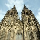
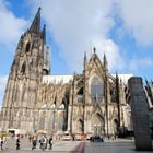
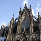
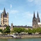
'Must visit' sights in Cologne
The first building on the site of the modern Town Hall was built in the early 15th century. The Town Hall was not restored seriously until the middle of the 20th century. The building stood in its...
Read further
The first building on the site of the modern Town Hall was built in the early 15th century. The Town Hall was not restored seriously until the middle of the 20th century. The building stood in its...
Read further
Cologne attractions and nightlife
Those, who can’t rest without fancy night entertainments, will find widest range of clubs and discos in the city. The opening of Koket club took place more than 50 years ago. All this time the...
Read further
Those, who can’t rest without fancy night entertainments, will find widest range of clubs and discos in the city. The opening of Koket club took place more than 50 years ago. All this time the...
Read further
Travel tips for Cologne
3. Local motorists are not distinguished by good knowledge of traffic rules. Therefore, you should be especially careful while crossing...
Read further
3. Local motorists are not distinguished by good knowledge of traffic rules. Therefore, you should be especially careful while crossing...
Read further
Maps of the region