

Printable maps of Cuernavaca


Interactive maps of hiking and biking routes around Cuernavaca
1. You can zoom in/out using your mouse wheel, as well as move the map of Cuernavaca with your mouse.2. This interactive map presents two modes: 'Biking Routes' and 'Hiking Routes'. Use the '+' button on the map to switch between them.
Railway and landscape maps of Cuernavaca area
This Cuernavaca map has two modes: 'Railway Network' and 'Landscape & Rural Map'. Use the '+' button on the map to navigate.City tours, excursions and tickets in Cuernavaca and surroundings
Nature and parks of Mexico
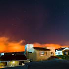
Isla Mujeres - literally "Women Island" - is a quiet paradise in the Caribbean Sea. It is named after the goddess of childbirth and medicine worshiped by the Maya. This is an inhabited island, but the water here is crystal clear, the sands are soft and white, and nature is fantastic. Here you can visit reefs and go diving, swim with whale sharks, visit a Turtle Farm where seahorses and other sea creatures also live and finally relax on the beach under the shade of palm trees. The water is very shallow in many areas. The island is good for watching the stars, as well as meeting sunrises and enjoying sunsets, which are especially beautiful here. … OpenPhotogallery of Cuernavaca sights
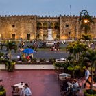
Our guide to Cuernavaca
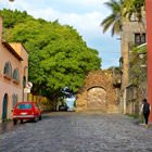
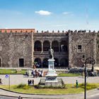
Cuernavaca sightseeing
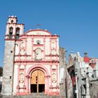
The Tlahuica civilization was the first group of people who permanently settled in the area of modern Cuernavaca in the 12th century. Xolotl, the ruler of Texcoco, conquered the Valley of Mexico in the 12th century. Until the 16th century, the American Indian settlement endured multiple attacks from the north. In 1521, conquistadors under the guidance of Hernan Cortes burned down the Indian settlement and … Open 