

Interactive maps of hiking and biking routes around Kremnica
1. You can zoom in/out using your mouse wheel, as well as move the map of Kremnica with your mouse.2. This interactive map presents two modes: 'Biking Routes' and 'Hiking Routes'. Use the '+' button on the map to switch between them.
Railway and landscape maps of Kremnica area
This Kremnica map has two modes: 'Railway Network' and 'Landscape & Rural Map'. Use the '+' button on the map to navigate.City tours, excursions and tickets in Kremnica and surroundings
Nature and parks of Slovakia
The Republic of Slovakia is a country located in the heart of the European continent. It does not have its own outlet to the sea. It has common borders with Austria, the Czech Republic, Hungary, Poland, and Ukraine. Slovak landscapes are predominately mountainous. On the Polish-Slovak border in the north-east of the country stretches the highest mountain range - the Tatra Mountains. The Carpathian Mountains stretch in the north of the country. About 75% of the country is located at altitudes of up to 760 meters above sea level. In the mountains of Slovakia, there are many lakes formed from the remnants of glaciers water. In Slovakia, there is only one lowland of Nitra, which is situated along the banks of the Danube on the border with Hungary. … OpenPhotogallery of Kremnica sights

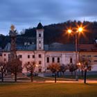
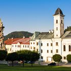
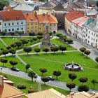
Our guide to Kremnica
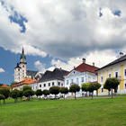
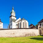
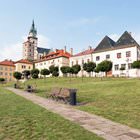
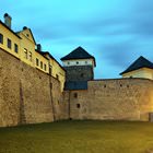
Kremnica sightseeing
Starting from the Middle Ages, Kremnica has been one of the main gold mining centers in the world – the region’s mountains are rich in this precious metal. First mining activities in the region started yet in the 9th century. Naturally, such rich deposits of gold couldn’t stay unnoticed. In the 13th century, the everyday life of local people was totally ruined by a Mongol invasion. Many people died … Open 