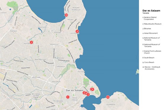
Detailed hi-res maps of Dar es Salaam for download or print
The actual dimensions of the Dar es Salaam map are 1530 X 1016 pixels, file size (in bytes) - 276168. You can open this downloadable and printable map of Dar es Salaam by clicking on the map itself or via this link: Open the map.
City tours, excursions and tickets in Dar es Salaam and surroundings
Moving around in Tanzania - transportation
 All major cities of the country are connected by railways. Their total length is about 4 000 kilometers. Trains vary in class. They have a first class, a sitting second class, a sleeping second class and a sitting third class. The first two classes of trains are characterized by minimal comfort options. Cars of the third class are not equipped with air conditioning and are always crowded. The price of the ticket is from 1 dollar to 5 dollars. The ticket allows you to cover a distance of up to 100 kilometers. Ferries regularly ply between the islands and the mainland of Tanzania. The vehicle can be either an old and rusty water transport or a relatively modern and comfortable ship. Therefore, the cost of tickets varies significantly.
… Open
Preferred to Open 9 New Hotels in 2022
In September 2022, the Sommerro hotel in Oslo will start operating in a carefully restored 1930s Art Deco building. This building is a true landmark of Frogner, a historic neighborhood of the Norwegian capital. A multi-million-dollar renovation carefully turned the largest preservation project in Norway into a modern hotel with 231 rooms, including 56 residences. Preferred will open five more hotels in 2022, namely, The Wall Street Hotel in New York, Amrit Ocean Resort & Residences on Singer Island (Florida, the US), TOA Hotel & Spa in Zanzibar, Pendry hotel in Washington, and Pendry Park City hotel in Utah. Read this
27.07.2024
In September 2022, the Sommerro hotel in Oslo will start operating in a carefully restored 1930s Art Deco building. This building is a true landmark of Frogner, a historic neighborhood of the Norwegian capital. A multi-million-dollar renovation carefully turned the largest preservation project in Norway into a modern hotel with 231 rooms, including 56 residences. Preferred will open five more hotels in 2022, namely, The Wall Street Hotel in New York, Amrit Ocean Resort & Residences on Singer Island (Florida, the US), TOA Hotel & Spa in Zanzibar, Pendry hotel in Washington, and Pendry Park City hotel in Utah.
27.07.2024
Search for services, infrastructure and sights on map of Dar es Salaam
Photogallery of Dar es Salaam sightseeing
Our guide chapters over Dar es Salaam
Dar es Salaam sightseeing
After the end of World War II, Dar es Salaam started developing actively. In winter 1961, Tanganyika finally became independent, and Dar es Salaam became its capital. When Tanganyika and the People’s Republic of Zanzibar merged to form a new country, Tanzania, it was decided to make another city the new capital. The process of changing the capital hasn’t finished yet. The national university opened in … Open 


 English
 Russian
 Dutch
Dutch German
 Spanish
 French
 Türkçe


