

Printable maps of Nanjing


Interactive maps of hiking and biking routes around Nanjing
1. You can zoom in/out using your mouse wheel, as well as move the map of Nanjing with your mouse.2. This interactive map presents two modes: 'Biking Routes' and 'Hiking Routes'. Use the '+' button on the map to switch between them.
Railway and landscape maps of Nanjing area
This Nanjing map has two modes: 'Railway Network' and 'Landscape & Rural Map'. Use the '+' button on the map to navigate.City tours, excursions and tickets in Nanjing and surroundings
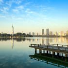
Nature and parks of China
The clearest lakes of China - Shudu, and Bita - can be found in the center of Potatso National Park surrounded by high mountains and thickets of rare plants. Jiuzhaigou is another Chinese nature park where you can see over a hundred lakes of completely different shades. This reserve is located in Sichuan, in the south-east of the country. Its name literally translates as "The Gorge of Nine Villages". Three valleys form the letter "Y" at their intersection. In this place, there is the magnificent Nozhilan Waterfall, which is more than 100 meters wide. The best time to come here is autumn when all shades of deciduous trees are reflected in clean waters of equally fantastic colors. … OpenPhotogallery of Nanjing sights
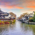
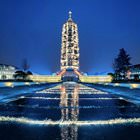
Our guide to Nanjing
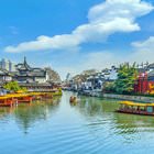
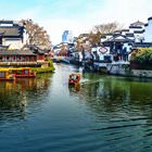
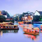
Nanjing sightseeing
How about looking at the symbol of Nanjing? For this purpose, visit the Zhonghua Gate or simply the Gate of China. This gate was built during the reign of the Ming dynasty. The construction is a defensive complex that includes the gate and high walls that surrounded the former capital of the Republic of China and protected it from enemy attacks. The construction is made of bricks – walls were thick enough to stop … Open 