

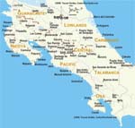
Maps of cities and regions of Costa Rica
Additional maps of Costa Rica


Fantastic City Tours and Excursions in Costa Rica
Country maps

Interactive maps of hiking and biking routes in Costa Rica
1. You can zoom in/out using your mouse wheel, as well as move the map of Costa Rica with your mouse.2. This interactive map presents two modes: 'Biking Routes' and 'Hiking Routes'. Use the '+' button on the map to switch between them.
Railway and landscape maps of Costa Rica
This Costa Rica map has two modes: 'Railway Network' and 'Landscape & Rural Map'. Use the '+' button on the map to navigate.Maps of cities and regions of Costa Rica

Escazu
The main natural attraction of these places is the Arenal Volcano. Its last major eruption occurred in the year 2000. The height of this volcano is 1,657 meters. It is located on the territory of the national park with the same name. Here on fertile soils, rare plants and flowers grow. Many rare birds and insects can also be seen here. Currently, the volcano poses no threat to the locals, despite the fact that sometimes there are small eruptions of lava. For tourists, watching them remains a … Read more 

San Jose
Cerro San Jose cliff is a significant natural symbol of the capital. Many travelers know it as The Mountain of Death. It's the highest point of Costa Rica. It is incredibly difficult to climb the mountain, many professional climbers have lost their lives while conquering the cliff. Once the Pan-American Highway is completed, it became possible to conquer the peak. There are guided walks on the mountains. Here, you can see a special species of tiny bamboo and rare species of fern, as well as … Read more