

Additional maps of Haiti


Country maps

Interactive maps of hiking and biking routes in Haiti
1. You can zoom in/out using your mouse wheel, as well as move the map of Haiti with your mouse.2. This interactive map presents two modes: 'Biking Routes' and 'Hiking Routes'. Use the '+' button on the map to switch between them.
Railway and landscape maps of Haiti
This Haiti map has two modes: 'Railway Network' and 'Landscape & Rural Map'. Use the '+' button on the map to navigate.Maps of cities and regions of Haiti

Port-au-Prince
The capital and the biggest city in Haiti – Port-au-Prince – comfortably lies on the bay that is a part of the Gulf of Gonave. Gorgeous local culture and the unique colonial architecture have always attracted foreign guests in search of exotic places where it is possible not only to relax but also to learn something new when exploring local attractions. Do you like making discoveries and learning something new? The voodoo cult is still alive in Port-au-Prince – this religion is exotic to … Read more 
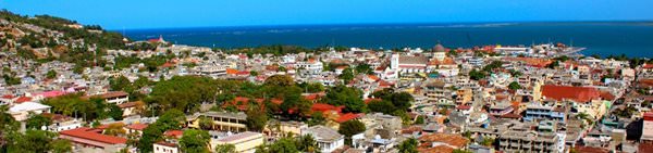
Cap-Haitien
Cap-Haitien is a port city on the coast of Haiti. This is the fourth-largest city in the country. It enjoys a fabulous location on the north coast of the island. Nowadays, Cap-Haitien is a major port city that, nevertheless, attracts a big number of tourists. Guests of Cap-Haitien can enjoy a striking view of the sea. Besides that, it is always a good idea to take a stroll on the city’s streets to see amazing buildings in Spanish style. Thanks to these buildings, the city had an unusual … Read more