

Maps of cities and regions of Faroe Islands
Additional maps of Faroe Islands
Country maps

Interactive maps of hiking and biking routes in Faroe Islands
1. You can zoom in/out using your mouse wheel, as well as move the map of Faroe Islands with your mouse.2. This interactive map presents two modes: 'Biking Routes' and 'Hiking Routes'. Use the '+' button on the map to switch between them.
Railway and landscape maps of Faroe Islands
This Faroe Islands map has two modes: 'Railway Network' and 'Landscape & Rural Map'. Use the '+' button on the map to navigate.Maps of cities and regions of Faroe Islands

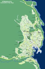
Torshavn
The main religious attraction in the city is Torshavn Cathedral. It was built in the 19th century and has remained the tallest building on the archipelago since then. The height of the cathedral is 40 meters. It has a very unusual pyramidal shape. Since the cathedral is currently the permanent seat of the bishop, only a part of its premises is available for guided tours. A very interesting historical landmark is located in the Kirkubor village, nearby. Here, you'll see the oldest wooden house … Read more 