

Printable maps of Tegucigalpa


Interactive maps of hiking and biking routes around Tegucigalpa
1. You can zoom in/out using your mouse wheel, as well as move the map of Tegucigalpa with your mouse.2. This interactive map presents two modes: 'Biking Routes' and 'Hiking Routes'. Use the '+' button on the map to switch between them.
Railway and landscape maps of Tegucigalpa area
This Tegucigalpa map has two modes: 'Railway Network' and 'Landscape & Rural Map'. Use the '+' button on the map to navigate.City tours, excursions and tickets in Tegucigalpa and surroundings
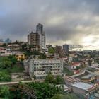
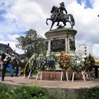
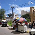
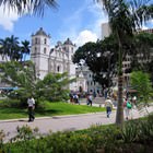
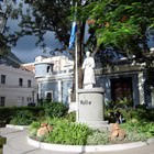
Photogallery of Tegucigalpa sights


Our guide to Tegucigalpa
Tegucigalpa sightseeing
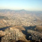
This resort is located in the southern part of Honduras. The name of the city can be literally translated as "silver hill". It was founded in 1536 as an industrial center, has long remained the largest mining area and a place of extraction of precious stones and silver. In 1880 the country’s capital was transferred to the city. After this the city began developing as an administrative center. Tegucigalpa will … Open 
Travel guide to Tegucigalpa
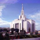
You should definitely come by the Honduras Historical Museum, which occupies a chic 19th-century building. It is considered the most beautiful architectural monument of the capital. The building is decorated with a spectacular dome, carved windows, and decorative balconies, slender columns frame its entrance. The museum presents a collection of unique archaeological finds relating to the days of Mayan culture and … Open