

Printable maps of Patan


Interactive maps of hiking and biking routes around Patan
1. You can zoom in/out using your mouse wheel, as well as move the map of Patan with your mouse.2. This interactive map presents two modes: 'Biking Routes' and 'Hiking Routes'. Use the '+' button on the map to switch between them.
Railway and landscape maps of Patan area
This Patan map has two modes: 'Railway Network' and 'Landscape & Rural Map'. Use the '+' button on the map to navigate.City tours, excursions and tickets in Patan and surroundings
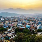
Nature and parks of Nepal
Nepal is not the right destination for fans of five-star hotels and white beaches. There is even no sea here, but the country can offer something different – exotic culture and ancient history. Bright colors, chaotic buzzing, majestic palaces, and poor mountain villages create a unique atmosphere of this country. Interesting excursions to such popular protected areas as Chitwan, Annapurna, Sagarmatha, and Banke simply cannot leave anyone indifferent. There are nine national parks in total in the country. Many tourists want to visit the mountains. Eight of the fourteen Himalayan mountains higher than 8,000 meters are located in Nepal. One of them – Mount Everest – is the tallest mountain in the world. Starting from the arrival in Nepal and until the last moments in this country, you will be charmed by the exotic atmosphere of this place. … OpenPhotogallery of Patan sights


Our guide to Patan
Patan sightseeing
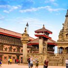
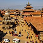
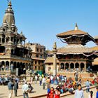
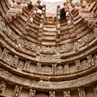
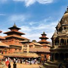
Lalitpur, formerly known as Patan, is a miraculous city five kilometers away from the capital of Nepal. This is the third-largest city in the country after Kathmandu and Pokhara. Lalitpur enjoys a fabulous location in the Kathmandu Valley. This is a region with numerous Buddhist pagodas and Hindu temples. In recent years, Patan has become a major center of culture and religion in Nepal. The city can be proud of its … Open 