

 English
 Russian
 Dutch
Dutch German
 Spanish
 French
 Türkçe
Detailed hi-res maps of La Palma for download or print

City tours, excursions and tickets in La Palma and surroundings
Moving around in Spain - transportation
 Spain is a modern country with highly developed infrastructure. Here you can find practically all the possible means of transportation that tourists can use to travel within the country. The airplane is one of the fastest ways to travel. Every major city of Spain has an airport in it, but they are located on the outskirts. The airports have domestic flights, which allow you to reach the necessary cities in a short time. This is especially true for traveling to the islands. In addition, the price of a ticket for domestic flights is often cheaper than the cost of other alternative modes of transportation. There is also a railway network in Spain. You can find railway stations in every major city. However, the cost of tickets for this mode of transportation is quite expensive. It is thus recommended to plan routes in advance and purchase travel cards, as this will be economical. You can also save cost if you purchase a return ticket. The train wagons are very comfortable and convenient. Usually, all of them are provided with air conditioning and toilets. However, some not very popular routes are run by old European diesel trains. The cost of tickets for such trains is cheaper, but they are less comfortable.
… Open
Spain is a modern country with highly developed infrastructure. Here you can find practically all the possible means of transportation that tourists can use to travel within the country. The airplane is one of the fastest ways to travel. Every major city of Spain has an airport in it, but they are located on the outskirts. The airports have domestic flights, which allow you to reach the necessary cities in a short time. This is especially true for traveling to the islands. In addition, the price of a ticket for domestic flights is often cheaper than the cost of other alternative modes of transportation. There is also a railway network in Spain. You can find railway stations in every major city. However, the cost of tickets for this mode of transportation is quite expensive. It is thus recommended to plan routes in advance and purchase travel cards, as this will be economical. You can also save cost if you purchase a return ticket. The train wagons are very comfortable and convenient. Usually, all of them are provided with air conditioning and toilets. However, some not very popular routes are run by old European diesel trains. The cost of tickets for such trains is cheaper, but they are less comfortable.
… Open Economy roadmap of Spain
Machine-tool construction in Spain also makes a significant contribution to the economy. Most of its production is geared towards exportation. Thus, Spanish machines and industrial equipment are supplied to more than a hundred countries around the world. Over a century ago, metallurgical activity began to develop in Spain. The main assets are located in the northern regions where there are large deposits of iron ore and coal. Non-ferrous metallurgy is focused on the extraction of lead and zinc. One third of the world’s mercury is produced in Spain. Also, there is located the largest deposits of pyrite. The energy sector is directly dependent on imports. The amount of domestic oil can only meet 7% of the country’s needs. At the same time, the majority of Fuel and Energy Complex works on oil and gas (approximately 68%). This state of affairs gave the country an impetus for the development of wind power. Spain’s share of wind power is about 10% of the total world’s volume. The state plans to build about two thousand mega watt of new wind farm. … Open
Car rental on OrangeSmile.com

Saudi Arabia to Open 38 Hotels in Diriyah
Diriyah is one of the first mega projects in Saudi Arabia. Hotels and other infrastructure will start opening next year, and all works are expected to end in 2026. The first 18 restaurants in Bujairi Terrace will start operating already in early 2022. Read this
18.04.2024
Diriyah is one of the first mega projects in Saudi Arabia. Hotels and other infrastructure will start opening next year, and all works are expected to end in 2026. The first 18 restaurants in Bujairi Terrace will start operating already in early 2022.
18.04.2024
Search for services, infrastructure and sights on map of La Palma
Photogallery of La Palma sightseeing

Our guide chapters over La Palma
Cuisine and top restaurants
Another attractive restaurant is La Pasta Real, which is perfect for both budget travelers and discerning gourmets. Absolutely everyone will be able to choose dishes they like on the extensive menu. A glass of your favorite wine will be a pleasant complement to the meal. As for budget restaurants, it is worth mentioning Café Sonata where besides national dishes you can order excellent desserts. There are always … Open 
Traditions and mentality of La Palma
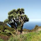
Locals believe that a big dragon once lived in these places. Its main victims were elephants that inhabited this land, but the biggest and strongest elephant has eventually managed to defeat the monster. When the dragon's blood spilled on the soil, the young trees soon appeared on it. It is believed that the real dragon blood is flowing through their trunks. The islanders ascribe a lot of amazing properties to the … Open
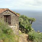
Travel guide to La Palma
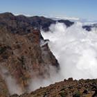
A walk along the slopes of the volcano San Antonio remains a popular entertainment thrill among adventurers. Unlike other parts of the island, there is a completely different, desert landscape. The last major volcanic eruption occurred in 1971, and today one can observe how smoke slowly rises from its crater. You can get acquainted with interesting historical sights of the island in the Veliko district, which … Open
La Palma for children - what to visit
In Garafia, an unusual museum - Parque Cultural La Zarza is located outdoors. It is a very beautiful park, on the territory of which, researchers discovered the most ancient petroglyphs. The park is very unusual. In its territory, there are many centuries-old trees and exotic plants, among which are hidden priceless historical artifacts - stones with the ancient drawings carved on them. A walk through this fabulous … Open
Shopping, streets and outlets
In the capital of the island, you can visit La Molina Artesania, an interesting shop that also features all kinds of national delicacies and souvenirs. Here they sell locally popular cookies in beautiful packages, various canned foods, all sorts of cheese and tea. La Molina Artesania presents a large selection of handicrafts made by local artisans, as well as wonderful wicker baskets, hand-painted mugs, and … Open
Advices for travellers
4. Those who still expect to take a bus should take into account an important nuance. Even though there is a timetable, not all drivers really care about it. 5. Spanish is widely spoken on the island, locals rarely speak other foreign languages. In hotels and bars, many employees understand English quite well but still prefer to answer in Spanish. 6. Siesta is common among local people. Every day at 1:00 pm … Open