

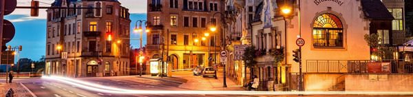
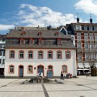
Printable maps of Koblenz

Interactive maps of hiking and biking routes around Koblenz
1. You can zoom in/out using your mouse wheel, as well as move the map of Koblenz with your mouse.2. This interactive map presents two modes: 'Biking Routes' and 'Hiking Routes'. Use the '+' button on the map to switch between them.
Railway and landscape maps of Koblenz area
This Koblenz map has two modes: 'Railway Network' and 'Landscape & Rural Map'. Use the '+' button on the map to navigate.City tours, excursions and tickets in Koblenz and surroundings
Germany - moving around the country
 Inside the city, you can also travel by bus and tram. You can buy tickets at any stop in special vending machines. At the same time, if you need to travel regularly on such mean of transport, it’s better to purchase reusable tickets. There is an opportunity to buy a ticket even for a month, which will help to save a lot. All bus and tram stops are equipped with special screens that show information about certain routes and the time before arrival. The tramway is well developed in lands of Bavaria. Some routes pass even under ground. Wealthy connoisseurs of comfort can rent a car or use their own. In doing so, it is worth to study traffic regulations in Germany attentively. It’s allowed to drive at a speed of up to 100 kmph; in towns the limit is 50 kmph. On autobahns, the speed of the car is not controlled at all.
… Open
Inside the city, you can also travel by bus and tram. You can buy tickets at any stop in special vending machines. At the same time, if you need to travel regularly on such mean of transport, it’s better to purchase reusable tickets. There is an opportunity to buy a ticket even for a month, which will help to save a lot. All bus and tram stops are equipped with special screens that show information about certain routes and the time before arrival. The tramway is well developed in lands of Bavaria. Some routes pass even under ground. Wealthy connoisseurs of comfort can rent a car or use their own. In doing so, it is worth to study traffic regulations in Germany attentively. It’s allowed to drive at a speed of up to 100 kmph; in towns the limit is 50 kmph. On autobahns, the speed of the car is not controlled at all.
… Open Nature and parks of Germany
Germany has an incredibly picturesque landscape; there are 14 national and 95 natural parks. In the north of the country, you can find ice. Dense forests prevail in the central part; the Alps are located in the south. Several large rivers - the Rhine, the Danube, the Elbe - are found here. There are numerous lakes too, the largest of which is the Bodensee. The largest national park, Schleswig-Holstein Watts, is located in the north of the country, on the coast of the Wattee Sea and occupies more than 400 thousand hectares. The park is in the UNESCO World Heritage List. Almost 2/3 of lands is regularly flooded during high tides or are permanently under water. There are about 10 million different birds, 2 000 species of insects; common porpoises, gray seals and horsehead seals live in the waters off the coast of the Wattee Sea. … OpenPhotogallery of Koblenz sights

Our guide to Koblenz
Cuisine and top restaurants
Those, who like sushi and rolls, wouldn’t find a better place to stay than a Sushi Bar Pirates. It has won recognition from customers thanks to a huge selection of treats, high quality of food and affordable prices. Sushi Bar Pirates differs with its decor and original artwork. Italian cuisine is promoted by Trattoria da raffaele. In the evenings romantic atmosphere and live music reign there. The specialties … Open 
Traditions and mentality of Koblenz
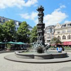
Today, absolutely any little boy can be called Schängel; this word no longer has any offensive overtones. The unusual sculpture on the main square has an interesting feature - the boy spits water every five minutes. Tourists who've decided to take a picture of the symbolic monument need to be especially careful and pay attention to wet spots on the asphalt. By them, one can predict the approximate trajectory of … Open
Travel guide to Koblenz
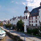
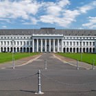
An architectural monument of the 18th century is the Palace of Electors. Originally it was built as a residence for archbishops. In the middle of the 19th century, the palace was the official residence of the Prussian royal house. For eight years, Prince Wilhelm lived there. This beautiful palace was almost completely destroyed during the Second World War. After the end of hostilities, it was restored in the … Open
Koblenz for children - what to visit
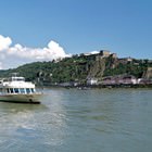
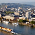
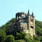
Near one of the main Koblenz attractions - namely, Deutsches Eck - is a wonderful place for walking. This is about Konrad-Adenauer-Ufer. It offers spectacular views of the confluence of the Moselle and Rhine rivers, which both adults and children will enjoy. As a bonus: Schloss Koblenz is also perfectly visible from here, its outlines will give you walk a certain charm. Since this is one of the tourist areas, it … Open
Advices for travellers
9. In restaurants and cafes tipping is required, 10% of the order would be sufficient. A small cash reward will also be appropriate to leave for the maid at the hotel and for the taxi driver. 8. Mains voltage is 220 V, all hotels are equipped with standard European socket. Before the trip, be sure to check for compatibility of all electrical appliances and chargers that you plan to take. 7. … Open
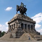
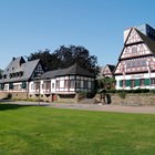
Attractions and active leisure
In summer, Freibad Lahnstein, a sports center located in the immediate vicinity of the city, is very popular with locals and tourists alike. Located in a picturesque park, it offers visitors large swimming pools with slides and equipped recreation areas. This sports complex is designed in a modern way so you can relax with comfort all day long. Spacious terraces for sunbathing are equipped for visitors, spaces for … Open